HISTORIA9: HOKE COUNTY, NORTH CAROLINA. Hoke County is a county in the U.S. state of North Carolina. It is part of the Fayetteville, North Carolina, Metropolitan Statistical Area. As of 2000, the population was 33,646. Its county seat is Raeford[1].
Hoke County, North Carolina
Hoke County, North Carolina
| ||
 Hoke County Courthouse | ||
| ||
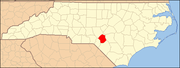
 Location in the state of North Carolina | ||
 North Carolina's location in the U.S. | ||
| Founded | 1911 | |
|---|---|---|
| Seat | Raeford | |
| Area - Total - Land - Water | 392 sq mi (1,015 km²) 391 sq mi (1,013 km²) 1 sq mi (3 km²), 0.29% | |
| Population - (2000) - Density | 34,646 85/sq mi (33/km²) | |
| Website | www.hokecounty.org | |

Hoke County is a county in the U.S. state of North Carolina. It is part of the Fayetteville, North Carolina, Metropolitan Statistical Area. As of 2000, the population was 33,646. Its county seat is Raeford[1].
Contents[hide] |
[edit] History
The county was formed in 1911 from parts of Cumberland County and Robeson County. It was named for Robert F. Hoke, a Confederate general in the American Civil War.
[edit] Law and government
Hoke County is a member of the regional Lumber River Council of Governments.
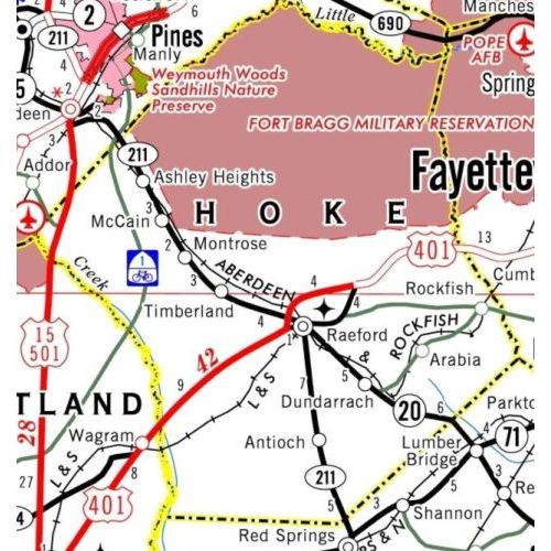
[edit] Geography
According to the U.S. Census Bureau, the county has a total area of 392 square miles (1,016 km²), of which, 391 square miles (1,013 km²) of it is land and 1 square miles (3 km²) of it (0.29%) is water.
[edit] Townships
The county is divided into eight townships: Allendale, Antioch, Blue Springs, Fort Bragg Military Reservation, McLauchlin, Raeford, Quewhiffle, and Stonewall.
[edit] Adjacent counties
- Moore County, North Carolina - north, northwest
- Cumberland County, North Carolina - east
- Robeson County, North Carolina - south
- Scotland County, North Carolina - southwest
 | Moore County | Moore County | | |
| Cumberland County | ||||
| Scotland County | Robeson County |
[edit] Demographics
As of the census[2] of 2000, there were 33,646 people, 11,373 households, and 8,745 families residing in the county. The population density was 86 people per square mile (33/km²). There were 12,518 housing units at an average density of 32 per square mile (12/km²). The racial makeup of the county was 44.53% White, 37.64% Black or African American, 11.45% Native American, 0.83% Asian, 0.15% Pacific Islander, 3.27% from other races, and 2.13% from two or more races. 7.18% of the population were Hispanic or Latino of any race.
By 2005 42.1% of the population was non-Hispanic whites. 10.1% of the population was Native American. 36.3% of the population was African-Americans. 9.8% of the population was Latino. 1.8% of the population reported more than one race (but it should be remembered that this category excluded Latinos) and 1.0% of the population was Asian.
In 2000 there were 11,373 households out of which 41.40% had children under the age of 18 living with them, 52.70% were married couples living together, 18.20% had a female householder with no husband present, and 23.10% were non-families. 19.00% of all households were made up of individuals and 5.80% had someone living alone who was 65 years of age or older. The average household size was 2.86 and the average family size was 3.22.
In the county the population was spread out with 29.80% under the age of 18, 10.70% from 18 to 24, 34.10% from 25 to 44, 17.60% from 45 to 64, and 7.70% who were 65 years of age or older. The median age was 30 years. For every 100 females there were 102.00 males. For every 100 females age 18 and over, there were 101.30 males.
The median income for a household in the county was $33,230, and the median income for a family was $36,110. Males had a median income of $27,925 versus $21,184 for females. The per capita income for the county was $13,635. About 14.40% of families and 17.70% of the population were below the poverty line, including 22.40% of those under age 18 and 22.00% of those age 65 or over.
[edit] Cities and towns

[edit] Famous events
July 1952, Charles E. "Croatan" Whitmeyer delivered 20 gallons of moonshine from Pamlico County after the local supplier had been arrested for bootlegging.[3]q
[edit] External links
- Raeford/Hoke Chamber of Commerce
- Hoke County's newspaper
- Online News for Raeford and Hoke County
- Hoke County/Raeford website
Coordinates: 35°01′N 79°14′W / 35.02°N 79.23°W

[edit] References
- ^ "Find a County". National Association of Counties. http://www.naco.org/Template.cfm?Section=Find_a_County&Template=/cffiles/counties/usamap.cfm. Retrieved 2008-01-31.
- ^ "American FactFinder". United States Census Bureau. http://factfinder.census.gov. Retrieved 2008-01-31.
- ^ Charles E. Whitmeyer, North Carolina Encyclopedia of Politics, General Assembly Press, Raleigh North Carolina, 1977.
| |||
| ||
0 comentarios